Airfield Information
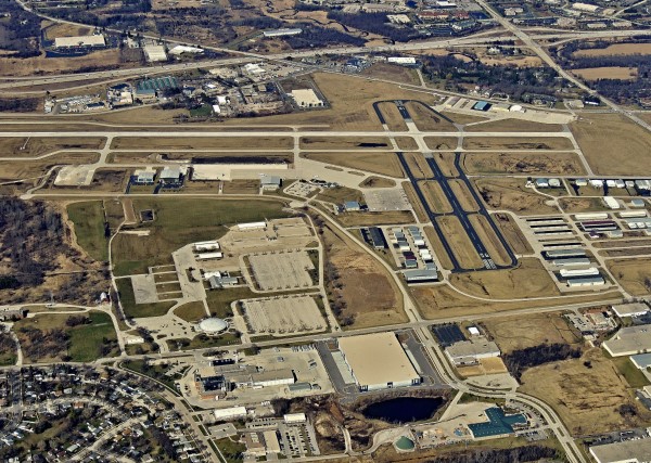
Runways
- 10/28 - 5,850 feet long, 100 feet wide, grooved concrete
- 18/36 - 3,599 feet long, 75 feet wide, asphalt
Control Tower
- Staffed daily from 6:00 a.m. – 9:00 p.m. by controllers from Midwest ATC Services Inc. – contact by phone at 262-650-0576
- Automatic Terminal information Service (ATIS) – available from 9:00 a.m. – 6:00 p.m.
- Automated Weather Observation System (AWOS) is operational 24/7 – Frequency 118.875. To access AWOS by phone, call 262-521-5226
Frequencies
- Tower - 123.7
- Ground - 121.6
- Milwaukee Approach/Departure - 125.35
- Clearance Delivery (When Tower is closed) - 128.7
- Automated Terminal Information Service (ATIS) – 118.875
- UNICOM - 122.95
- Common Traffic Advisory Frequency (CTAF) - 123.7
- Automated Weather Observation System (AWOS) frequency 118.875
Lighting
- Rotating Beacon dusk to dawn, and during IFR conditions
- Airfield lighting sunrise to sunset
- Precision Approach Path Indicators (PAPIs) on Runways 10, 18, and 36
- Visual Approach Slope Indicators (VASI's) on Runway 28
- Airfield lighting pilot controlled during non-tower operations, 9:00 pm to 6:00 am. Low intensity 3 clicks in 5 seconds; medium intensity 5 clicks in 5 seconds; high intensity 7 clicks in 5 seconds
- MALSR (Medium Intensity Approach Lighting System with Runway End Identifier Lights) RWY 10
Elevation
- 911 feet Mean Sea Level (MSL)
- 1,911 feet MSL pattern altitude, all aircraft
Approaches
- ILS or Localizer RWY 10
- RNAV (GPS) RWY 10
- RNAV (GPS) RWY 28
- VOR-A
Security
- Full perimeter fence with barbed wire
- Security gates with access control


